Until the 20th century, the Freshwater region was predominantly an agricultural area, made up of small hamlets and farmsteads, scattered throughout Freshwater Isle amongst a mixture of enclosed and open field systems. Even in the 19th century, there was no centre to the settlements in the area. From Saxon times, the parish instead consisted of small pockets of habitation, each sited around a green: More Green, Freshwater Green, Pound Green, Sheepwash Green, Middleton Green, Stroud, Easton, Norton and the settlement round the parish church. However, there were two areas of significant settlement: one centred around School Green and another crowding around the west end of the parish church, in what is today called Church Place. Small fishing hamlets existed at Freshwater Gate, Brambles Chine and Norton. The downland, known as High Down, which runs along the southern edge of the parish on top of its chalk cliffs, provided valuable pasture for sheep.
The population of the whole region fluctuated around the 500 mark during the 17th century. The majority of people earned a living from agriculture: between 1571 and 1700, almost 75% of wills in Freshwater state a person’s occupation as ‘Yeoman’ or ‘Husbandman’. The other occupations were allied agricultural trades such as blacksmith, miller and carpenter, and service trades, including grocer and butcher. Some also found an additional source of income by descending the cliffs on ropes either to catch sea birds or to collect samphire. The birds were sold for their feathers and as bait for crab traps:
“The country people take the birds that harbour in these rocks, by the perilous expedient of descending by ropes fixed to iron crows…thus suspended, they with sticks beat down the birds as they fly out of their holes; a dozen birds generally yield one pound weight of soft feathers, for which the merchants give eight pence; the carcases are bought by the fishermen at six pence per dozen, for the purpose of baiting their crab-pots.”
(History of the Isle of Wight by Sir Richard Worsley. London, 1781)
In the early 17th century, the digging of pipe clay also occupied some of the inhabitants of Freshwater; it was sent to London to be used in the manufacture of tobacco clay pipes. This same clay was also in demand for making the crucibles in which molten glass was contained during the glassmaking process. Some inhabitants were employed in digging the white sands at Alum Bay for use in manufacturing glass. Chalk was quarried from pits along the north edge of Tennyson Down for use on the fields or for burning into lime in order to make mortar for building. Two lime kilns, possibly dating from the 17th century, can still be seen on Moons Hill. Certain strata of chalk was solid enough to be used in building and many of the old stone cottages and farm buildings have an element of chalk block in their construction. Hard, ferruginous sandstone, which occurs in thin layers amongst the softer sands, was also used in construction of walls. This availability of different types of stone meant that many of the humbler dwellings and farm buildings are invariably made from a variety of these stones, usually chalk block and sandstone (often so laden with iron as to be termed 'ironstone').
Being somewhat isolated from the rest of the Island, a rural outlook and psyche shaped the locals’ values, lifestyle and culture. They lived according to an agrarian calendar that had changed little in centuries, shaped by the seasons, agricultural events, and religious holidays and festivals. The church was central to the community: the rector or curate presided over births, marriages and deaths, and as one of the few educated men in the area he was an obvious source of advice. He acted as a guardian of local morality and oversaw his parishioners’ spiritual wellbeing. The stocks for the area were located outside the churchyard gate, where a miscreant could be assured maximum exposure to the view of the inhabitants.
Originally, there had been only two means of access to Feshwater Isle: by ferry boat at Norton across the mouth of the Yar estuary to Yarmouth, and by foot across a narrow neck of land called Freshwater Gate at the southern end of the creek formed by the River Yar. This neck of land consisted of a bank of shingle that separated the sea to the south from the marshes of the upper reaches of the Yar estuary to the north. G. Brannon wrote of Freshwater Gate in the mid-19th century:
“A low narrow bank of shingly pebbles that are thrown up by the furious waves, here interposes between the briny element and the spring-head of the river Yar, which is supposed to have given the inappropriate name of "Freshwater" to this part of the Island: it rises in a meadow nearly opposite the hotel, and taking a northerly direction, communicates with the Solent Channel at Yarmouth: of course, if ever the present shallow barrier of shingles should be removed, this quarter will then be completely insulated, as is said to have been the case some centuries back.”
(Vectis Scenery by G. Brannon. Wootton, 1824)
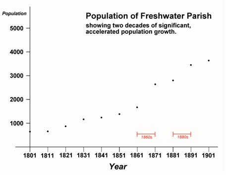
Graph 1
However, by the 17th century another communication link had been added in the form of a causeway, which extended from the parish church of All Saints to Afton. This causeway was possibly constructed as the dam wall for a tide mill that existed by the mid-14th century. By 1694, this was described as a “water corn mill”. At some point, Black Bridge was built over the Yar marshes, thus avoiding the longer route to the south via Freshwater Gate. By the mid-18th century there were two windmills in the area: one on a hill east of Weston Farm, and another near Freshwater Green. The nature of roads in the area can be seen in Helen Allingham’s 19th century paintings of the cottages at Freshwater. The roadway is made of compacted gravel and is only wide enough for one cart. There are no definite edges or kerbs so grass and weeds grow right up to the roadway, which therefore varies in width.
The building of the forts and batteries in the Freshwater region and the consequent influx of troops into the area during the 1860s and 1880s led to a significant rise in the population of Freshwater (see graph below). Not only was there a large military presence, but this was also one factor contributing to the demand for a wide range of ancillary service trades, which attracted an increase in the civilian population too.
GLOSSARY
husbandman: A tenant farmer or small landowner, lower in status than a yeoman.
yeoman: From the late 14th to 18th centuries, a yeoman was a farmer who owned and cultivated a small landed estate.
Based on the ‘Analytical Record’ of Farringford by Robert Martin: